Saturday, September 18, 2010

I have not figured out how an entire week goes by without finding time to write a blog entry... So, here it is Sunday in McMurdo again. And it is really windy again, so probably no hiking today, on our one day off.

There has been both good news and bad this week regarding the long-duration balloons. There have been four launches, which is all of the payloads intended for studying the "ozone hole". Unfortunately, though, the balloon control center lost contact with the first balloon payload early this week. The balloon itself and the control systems were working fine, but they could not talk to the scientific payload at all. They tried for three days to regain communication, but were unsuccessful.  In some ironic stroke of fortune, though, the balloon was heading back toward the McMurdo area, which allowed for the possibility of destroying the balloon and retrieving the payload. This procedure was done early in the morning one day this week and the payload landed about 60 mi from McMurdo. The hope is to retrieve the payload as soon as the helicopters start flying (around the 28th of Sept).

Meanwhile, three payloads are floating above the Antarctic continent and seem to be returning excellent data about ozone and nacreous cloud particles. Through the miracles of modern technology, we receive our data via the internet every hour! The control center in Toulouse sends a query to the payload via Iridium satellite and the payload management software responds by sending down packets of data, also via Iridium. So, within about an hour of a measurement being taken, we know what the ozone amount is! Below is a  Google Earth map of where the 3 balloons are as of this morning. We hope they will all stay afloat for several weeks, if not months, providing us with lots of data about the formation of the "ozone hole".


Trajectories of the 3 long-duration balloons from launch to current position.

It is finally getting to the time of year when the sun is up for a normal day's length; soon it will be up 24 hours a day! McMurdo and the surrouding areas look quite different when the sun is really out than in many of the pictures I've posted before. So, I thought I would share some of these, just for fun.

Little chunks of clear ice glowing in the sun.

Balloon launch on a sunny, clear day!

Even though the sun is up, it is still low on the horizon - look at that long shadow!

Finally, I wanted to share another fun thing we get to see here fairly often. It is a mirage called "Fata Morgana", which is named after a character in the legend of King Arthur (Morgan Le Fay). She is generally regarded as a sorceress or magician and the application of her name to this mirage seems appropriate. It is also fairly common at sea, I understand. The mirage occurs when there is a layer of very cold air near the surface and a layer of much warmer air above it. You can imagine that, with all the ice and glaciers around here, the surface air is often quite cold. The difference in temperature bends the light, making distant objects look much bigger than they are.  See for yourself below - this is the largest Fata Morgana that any of us can recall having seen here.

Fata Morgana at the base of Mt. Discovery. In truth there is no cliff there at all!

Monday, September 13, 2010

Launch #2: Ups and Downs

Before anyone panics over the title of this post - the "down" does not refer to a payload falling out of the sky (thank goodness!). Nonetheless, there is plenty of drama from the past few days to share.

As I had hoped at the end of the previous post, the weather was cooperative and CNES planned a launch of payload #2 (carrying the CU ozone instrument and University of Wyoming particle counter) for the morning of Saturday 11 September. It was still a bit windy as the crew was setting up and inflating the balloon, but the forecast had called for the winds to die off by late morning. Unfortunately, that forecast did not hold up and the crew had to take some unusual measures on the launch pad - for example, tying the launch table (which is on wheels) to their passenger van to keep it from rolling across the ice in the wind. Below are a couple of pictures from this launch attempt. Sadly, just before launch, a very large wind gust knocked the balloon onto the ground and the director aborted the launch. They could not be sure that the balloon had not been damaged by hitting the ground. Better safe than sorry!
The wind blimp (know by the French as "Le poisson" - the fish).
It's very windy when the tails are straight out and the line makes a sharp angle to the surface.
Balloon blowing in the wind - it took four big guys to hold the table in place.
Fortunately, the winds calmed to almost nothing in the afternoon, allowing for a picture-perfect launch!

Wheeling the payload and control module out for launch.
Both are covered in solar panels to provide power to the instrumentation.
Release!!

Payload 2 took off smoothly and rose to an altitude of 17 km (about 10 mi) in a couple of hours. It was in a pretty fast wind, moving toward the east at about 50 mph. After performing flawlessly for almost 24 hours, we suddenly stopped getting data from the instruments. Based on the amount of power being consumed, we knew the instruments were running, but no data was being transmitted back. No one could figure out what had gone wrong and the 10 hours' time difference between here and Toulouse (the home of CNES) made debugging the problem very challenging. We debated the wisdom of launching another payload without knowing what had happened to #2 and left for dinner yesterday feeling pretty down. However, during dinner, some in France worked their magic and re-established communications - we checked for data several times yesterday evening and again early this morning. Happily payload #2 seems to be back on line... and payload #3 took off about 2 pm today (Tues 14 Sept).

Above is a map of the path of balloon #2 since its launch. Forecasts suggest
that it will head back in toward the continent soon.


Thursday, September 9, 2010

The First Launch!!

I'm really pleased to report that the first Concordiasi balloon was launched yesterday morning (9 September) around 9 am. We woke up to a cold (about -35 oC) but completely calm morning and the French launch team took full advantage of the conditions. The gondola and the instruments are functioning perfectly (I'll talk more about those and post some other pictures in a day or so). The balloon is moving at about 25 mph at an altitude of about 16.5 km (a little over 10 mi).

We are hoping for a second launch tomorrow morning; this will carry one of the University of Colorado instruments, so I am particularly eager to see it go.

The launch site - the bubble of the balloon is visible in the center.


Release!! Notice the shower of blue - that is a soft plastic collar that holds the
balloon in place on the launcher. The little yellow blimp on the right
is used to gauge the wind direction


Climbing. The guys to the right of the balloon are still holding the payload,
waiting for the launch train (the stuff that connects the balloon and payload)
to straighten out.


The balloon rising into the sky. Beneath it are a parachute, a control module and
the gondola with the scientific instruments.

Tuesday, September 7, 2010

Patience

The past few days here have given us all a lesson in patience. On Monday (not a holiday in Antarctica), things looked pretty good for a launch in the afternoon. The French team took care of a few final details at their launch site (see the picture below) and waited for the winds, which were calming down (they really need wind speeds below 6 knots (nautical miles per hour) = 7 mph). At about 3 pm, they were within 10 minutes of being ready to inflate the first balloon when they encountered a small problem that forced them to cancel. In the end, this was a good decision, because only 30 minutes later, the winds were howling again and they would almost certainly have destroyed the balloon. Nothing to do but wait...


The balloon launch site, including the two "rac tents" (yellow) where the balloons
are prepared. The airport control tower is not part of the launch facility;
it is just "parked" nearby until the Ice runway is ready.
Still, wouldn't it be cool to have your own control tower??

Since Monday, the winds have been out of limits (averaging about 20 mph, with gusts well over 40 mph) except for a brief period at dinner time yesterday. Today there was so much blowing snow that the launch site was under Condition 1, which means no one can go there. Just as well, as the winds in the stratosphere (where the balloon will end up) would have carried a balloon launched today into darkness within a couple of days. Since the balloon systems are largely powered by solar-recharged batteries, this would have meant a flight of only 4-5 days' duration. So, we wait some more...

And, on the home front, we have learned a lot about patience while waiting for news about the wildfire west of Boulder. Two of our colleagues here own homes in the area and both spent most of yesterday on the internet trying to find out any information they could. We all know other people who live in that area and assume that they have been evacuated and are safe. One colleague here heard from his son that he had gotten to the house and picked up the dog before the fire reached there; the other was waiting to know if his tenants got out safely. The good news today is that everyone is safe; the bad news is that one house was confirmed to be destroyed by fire (the colleague's son actually found pictures of the house on fire on a local TV website). We don't know for certain about the other house... more waiting!

Sunday, September 5, 2010

Hiking!!

Life at McMurdo can really be very strange! Yesterday, only moments after I finished the previous post, the winds did calm down, so I went for a short (about 3 mile) hike with some colleagues. Along the way, we were commenting that we would probably never consider going for a hike in weather like this at home. The temperature was about -25 oC (-13 oF), but the sun was out and there was very little wind. Nonetheless, that meant (for me) wearing long underwear, my down pants, a fleece jacket, the "Big Red" parka, a hat, a neck gaiter, glove liners and mittens. I did wear my personal hiking boots instead of the ECW pair (which I find hard to walk in), along with two pairs of socks. I was actually very comfortable during the hike - even a bit too warm at times, which meant unzipping the parka and taking off the mittens. Did I mention that it takes at least 5-10 minutes to get dressed for this kind of activity?  You do get used to it after a while....

We hiked the Observation Hill Loop. This is a new trail since the last time I was here and it circumnavigates Observation Hill, a prominent peak (750 ft above sea level) on the east edge of McMurdo. I'm sure we'll have a chance to climb Ob Hill before leaving here - it's well worth the effort on a clear day. In any case, the Ob Hill Loop was very nice - great views of Scott Base (the New Zealand station that is 2 miles from here) and of the Ross Ice Shelf and mountains to the south. In addition, it was extremely quiet on the back side - at one point all we could hear was the wind. Below are some pictures from the hike.

Ob Hill,  looking up from the start of the
loop trail
The new wind turbines; together they provide 1 MWatt of power to the US and New Zealand stations.


Windblown snow along the Ob Hill Loop trail


McMurdo Station from Ob Hill Loop Trail. The helo pad is in
the foreground; the Crary Research Lab is the tan building in the
center of the photograph.

Mt. Discovery and stack of lenticular clouds
My fellow hikers, enjoying the view of the Ross Ice Shelf

Saturday, September 4, 2010

Waiting...

I can hardly believe that an entire week has gone by since my last post. It has been a fairly typical week here, which, to me, means that the work is going OK and the days are starting to blend together. The bad news is that we have yet to launch a long-duration balloon - hence, the title of today's post. The French launch team has been busy preparing their equipment and the first balloon gondola, while the carpentry shop has finished building the "rac tents" for the launch site. Much of this activity was delayed by last week's storm, but all is complete now and ready for use! We are keeping our fingers crossed that the weather cooperates for a couple of launches this coming week.

Meanwhile, we have been testing our instruments, currently scheduled to fly on Flights 2 and 3, to verify that they are ready. Everything appears to be in order, so we will work this week on our spare instruments in case they are needed or other launch opportunities arise.

Outside of work, this has been a pretty nice week. We had four days in a row of spectacular polar stratospheric clouds. No one can remember ever seeing as many or seeing them spread so far across the sky in past years. It has been fun to watch people in the science building (Crary Lab) get excited about this; every day about 3:30, you would see noses pressed to the windows and people running for their coats and hats with cameras ready to capture the beautiful colors. I know I've posted some pictures of these clouds earlier, but I can't resist one more. I especially like this because it also includes the setting sun! 1 September was the first day we saw the sun in town.


So, today is Sunday in McMurdo, and that is the one day off for the staff here - they work 7:30 am to 5:30 pm Monday through Saturday. Some departments obviously need to have people work on Sundays (the kitchen, for example), so their shifts are somewhat different. Saturday evening is usually the big "party night" here  - there are often private parties held in dorm lounges or other places around station, plus plenty of folks gather at one of the bars (there are two) or the coffeehouse (which also serves wine). There's also usually at least one movie being shown - sometimes at the coffeehouse, sometimes in the galley. Last night there was a little craft show at which people were showing and selling hand-made knit goods, artwork, etc. It was a pretty small affair (there is a much bigger show held later in the season), but a nice opportunity to chat with some of the people working here.

I will sign off now and hope that the winds die down enough to go for a walk this afternoon - if not, I have books to read, videos to watch, etc.  Plenty to keep me occupied while I wait...

Saturday, August 28, 2010

The Beauty of Antarctica

Since work is a bit slow right now (not that we aren't busy, just not with anything of particular interest to share), I thought I would show you some examples of the beauty of the McMurdo area. This is definitely one of the reasons I am willing to come back here, in addition to this being a place to do good research. McMurdo Station itself is not that attractive a place (you can find lots of pictures of it online) - the land is simply volcanic rock with a light covering of snow (right now - in a couple of months it will be mud and dust). Many of the buildings are left from the Navy days when McMurdo was a military installation, so it resembles an aging, bland harbor town.

The scenery, on the other hand, is quite beautiful (at least in the eyes of most of us; if you like trees and green things, you won't like it here!).  McMurdo is on the southern side of Ross Island - to the south of us is Mt. Discovery (an extinct volcano) and to the west is the Royal Society range of the TransAntarctic Mountains. Both are quite photogenic, especially with the low sun angles we currently have here.

Mt. Discovery yesterday morning. The shadow on the lower slopes is cast by
Mt. Erebus, which is to our north, between us and the sun. The vehicles in the
foreground are working to prepare the ice runway that will be use starting in October.

Of course, the low sun angles this time of year make for some spectacular lighting. It is impossible to capture every beautiful moment, but here are a couple of recent examples. The colors are real - I have not manipulated these images and I think the camera captured them well.
Sky toward sunset - the purple is the very thin polar stratospheric clouds I described in a previous
post. I liked the reflection of the sky colors in the windows of the lab in the foreground.

The western sky after sunset last night, looking toward the Royal Society Range.
The color beneath the mountains is ice fog!


Finally, I would be remiss if I did not comment on the awe-inspiring night sky here.  Unlike what we are used to seeing in the Northern Hemisphere (when we can see the stars, that is ), the Southern Hemisphere is dominated by the Milky Way. The first time I saw this, I literally fell over. We have been fortunate to have some very clear nights this week. Last night I decided to go out for a look with a colleague. I borrowed a tripod from the lab and decided to experiment with my new camera. You can judge the results for yourself below (and this is just a tiny piece of the sky, so imagine seeing this kind of stuff from horizon to horizon).

Does this need a caption??

Thursday, August 26, 2010

A little more about the science

We've had a truly beautiful day here today - the sky was clear and blue (although we do not see the sun here in McMurdo for a few more days because we face south and have some big obstructions to our north) and after lunch, we noticed an abundance of polar stratospheric clouds (PSCs) to the west.  People also know these as nacreous clouds or mother-of-pearl clouds.

PSCs are one of the key players in stratospheric ozone depletion. They are naturally occurring clouds residing 12-25 km (7 - 15 mi) above the surface and are composed of either pure water (if they are very cold, -85 oC/-121 oF) or a mixture of nitric acid and water (nitric acid trihydrate or NAT), around temperatures of -77 oC/-107 oF. PSCs provide a surface that catalyzes reactions between gas-phase molecules that would not otherwise react with one another. This, in turn, leads to conversion of chlorine-containing gases (derived from chlorofluorocarbons) into forms that react quickly with ozone. So, seeing PSCs means ozone depletion is occurring overhead. As you can tell from the picture below, it is also awe-inspiring, because they are beautiful.
Polar Stratospheric Clouds west of McMurdo - 27 Aug

For the PSC aficionado - this photo contains both Type 1 (NAT) and Type 2 (ice) PSCs. The Type 2s are the ones that are iridescent or brightly lit; the Type 1s are the hazy, grayish ones surrounding the Type 2s. You would not necessarily know that from the photo, but we were treated to the most gorgeous purple glow as the sun continued to set, confirming the presence of the NAT clouds throughout the sky.

Another piece of science being done here is the regular launching of ozone sondes - small balloons that carry a package to measure the profile of ozone from the surface to somewhere up in the ozone layer - 25 to 30 km, or wherever the balloon bursts. Terry Deshler's group from the University of Wyoming is doing this work, so I tagged along yesterday to photograph one of their launches. They'll be launching an ozone sonde about every 3 days to watch the progression of the ozone depletion over the next 6 to 8 weeks.

Inflating the ozonesonde balloon. Most of the
balloonis contained in that white bundle on the tarp.
Releasing the balloon - the person on the left is holding the sonde. He'll wait for the balloon to get overhead before letting go.

Wednesday, August 25, 2010

The purpose of our trip

Now that I've posted a couple of general items, I suppose it is time to talk about why we're here in Antarctica in the late winter. As many of you know, one of my fields of research is stratospheric ozone chemistry and Antarctica is "ground zero" for studying ozone depletion as it is happening. In fact, the annual Antarctic "ozone hole" is beginning to grow overhead here as I type (well, not really that quickly, but definitely faster and faster as the days go on and as the amount of sunlight increases).

This year, there is a special project taking place from McMurdo Station to study the "ozone hole" - it is called Concordiasi and it is coordinated by colleagues from France (at Meteo France and CNES, the French Space Agency). The folks at CNES have developed a special type of high altitude research balloon - called a super-pressure balloon - that can carry a smallish payload to the stratosphere and stay aloft for a long time  (perhaps as much as 6 months!). We are privileged to be part of the team of scientists flying instruments on these payloads. My group will be measuring ozone - in the "ozone hole" as it is developing!

So, there is a group of 12 scientists and technicians from France who will be coordinating the balloon launches and gathering data back from the payloads (via satellite). And there are three science groups - ours, one from the National Center for Atmospheric Research (NCAR) in Boulder, and one from the University of Wyoming. We'll  fly instruments together with the Wyoming folks (who will measure the cloud particles linked to ozone depletion). The NCAR group has a separate payload of so-called driftsondes, which are small devices to measure temperature, humidity and pressure profiles when dropped by parachute from the orbiting balloon gondola.

The bad weather here has delayed us a bit  - there is a lot of preparation work yet to be done, especially building the launch site out on the sea ice. But, we are aiming for our first launch to take place on 2 or 3 Sept, weather-permitting.

You can learn more about Concordiasi from this article published in the Antarctic Sun, which is the "local" newspaper.

Today's visual is a time-lapse video shot by my post-doc Lars, showing some of the French group unpacking and setting up their equipment.

Tuesday, August 24, 2010

It's all about the weather

I have avoided saying much about the weather until now because there's something of a superstition here about it. One should definitely not comment too much about how nice it is - warm (relatively speaking), calm, etc. - for fear that will change for the (much) worse. So, now that it's bad weather, I feel comfortable talking about it.

First, to be clear, "good weather" in Antarctica this time of year would generally not be considered good weather anywhere else. The August-September time period (known here as WinFly, short for Winter Fly-in) is widely acknowledged to have some of the nastiest weather. Not necessarily the coldest, but certainly the windiest (wind chill is a big concern) and often the stormiest. Average temperatures for August are a maximum of -4 oC (+25 oF) and a minimum of -49 oC (-56 oF). The peak wind recorded for August was 100 mph!

Yesterday, a storm started here. It's been snowing pretty much continuously for at least 36 hours. It is hard to know how much accumulation there has been because the wind is blowing like crazy (sustained at 20 mph, with gusts up to 35 mph or so). It's not really that cold - the air temperature is around -23 oC (-9 oF) - but with the wind and snow, it's pretty nasty out there. In fact, the visibility is terrible, which means that work outside of town has shut down completely.

To make it easier to communicate about the weather here, they have established a "condition" system. Condition 3 means it is safe to be outdoors, even for recreational travel. Condition 2 means that either the wind chill or visibility have gotten to the point where only those who really need to be outside (for work) should be. And Condition 1 means no one should be outside (in fact, we are confined to the buildings we're in if Condition 1 is called). Right now, the station itself is at Condition 2, but all of the surrounding areas are at Condition 1. It's really starting to feel like "authentic" Antarctica, rather than the warm, calm, clear days we had right after we got here!

Observation Hill from Crary Lab on a clear day
(yes, that's the moon) - 1/3 mi away
NSF Chalet building from Crary Lab, today
300 ft away

Sunday, August 22, 2010

Getting here is half the fun!

So, the first questions that people usually ask (after what the heck are you doing there?) is how do you get there? How long does it take?

First a little geography - McMurdo Station is located on Ross Island (almost 78 S and 166.5 E). This is on the New Zealand and Australia side of the continent, not on the South American side. So, getting here first involves a trip to New Zealand, where the US has maintained a logistics center since the 1950s. On this trip we flew from Denver to Los Angeles; LA to Auckland, New Zealand (north island) and then Auckland to Christchurch (south island). Yes, it's a long trip - about 24 hours or so, airport to airport. But, the good news is that the LA to Auckland flight left LA at about midnight, so we got plenty of sleep during the trip.

Once in Christchurch, you usually have a day or two of activity. We arrived on Wed, 18 August and checked into a nice B&B that the US Antarctic Program (USAP) uses regularly. On Thursday, we (and a lot of our fellow travelers) had an appointment at the Clothing Distribution Center (CDC) to get our Extreme Cold Weather (ECW) gear. That is about 35 lbs of clothing designed to protect you from the elements and make living and working here comfortable and safe. It is generally an amusing experience to try on all of these clothes and to realize that most of the time you're going to feel like the Michelin man (or the little brother from the movie A Christmas Story). This year, we also were all given flu shots at the CDC. Apparently there was a pretty serious outbreak of flu a couple of seasons ago and they are trying to prevent a repeat.

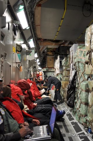
On Friday, 20 August, we all got up around 3 am and took shuttle buses back to the CDC (which is located near Christchurch airport). We repacked bags and got into our ECW gear for the flight (it's required to wear it). The CDC personnel had arranged for a mobile coffee cart to come around 4 am (seriously, the guy had an whole coffee bar in the back of a van!), which was really helpful! Caffeinated and bundled up, we all checked in our luggage, got boarding cards and eventually went through security - just like a normal flight. Then onto more buses and off to the airplane. The USAP contracts with the US Air Force to fly C-17 transports to Antarctica now - it's a pretty nice way to go. There was so much cargo in the plane, though, that I couldn't get a good picture of the interior. We were all seated along the side walls and the center was filled with materials, crates, gas cylinders, luggage, food, etc..

Outside the passenger terminal, 5 am


Passenger seating in the C-17

One great thing about this trip was that the weather was perfect! It was so nice, in fact, that the flight crew invited us up onto the flight deck (2 at a time) to see the view. I couldn't photograph from up there very well, but here are some images taken out one of the side ports. Be sure to look at the shadows - the sun was really far north!

A break in the sea ice (called a "lead")
Looking north - look at those shadows!


First few of the Trans-Antarctic Mountains


Then, 5 hours after we left Christchurch, we landed at the Pegasus runway (a permanent runway on the Ross Ice Shelf). It was about noon local time and really quite warm (maybe -30 C, warm for this time of year!). It then takes about 45 minutes to get to McMurdo by bus... more on McMurdo itself in another post!

Folks arriving off the C-17

Antarctica?!!? What the heck are you doing there?

If I had a dime for everytime someone has asked me that question.... But seriously, welcome to a little blog I'm going to try to keep for this season's visit to the highest, driest, coldest, windiest continent on Earth. My postdoctoral researcher, Lars Kalnajs, and I are at McMurdo Station, Antarctica to participate in a special project to study the ozone layer here. Over the next few weeks, I'll let you know more about the project and about life in McMurdo. Feel free to send questions, too, if there's something you want to know more about.

For now, though, I'll leave you with a link to the McMurdo Station Webcam (which works most of the time - except days like today, when it is covered with snow).

http://www.usap.gov/videoclipsandmaps/mcmWebCam.cfm